Evacuations extended near northern Illinois industrial fire
Jul 1, 2021

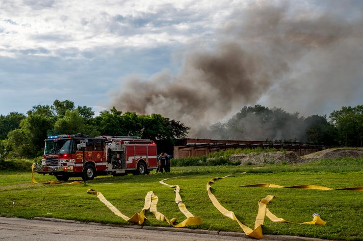
Toxic fumes and smoke from a burning former paper mill in northern Illinois that officials had believed was long abandoned but actually contained massive amounts of lithium batteries prompted officials to extend an evacuation order for the area

CHICAGO (AP) — Toxic fumes and smoke from a burning former paper mill in northern Illinois that officials had believed was long abandoned but actually contained massive amounts of lithium batteries prompted officials to extend an evacuation order into Thursday for residents in the area.

The Illinois Environmental Protection Agency on Thursday also asked the state’s attorney general to pursue legal action against Superior Battery, the property owner, for contaminants released into the air and water as well as for improperly handling waste.

The fire that started in Morris around midday Tuesday prompted city officials to order the evacuation of 3,000-4,000 people in some 950 nearby homes, a school, church and small businesses.

Reached by phone on Thursday, building and company owner Jin Zheng said he had hoped to start a business selling the batteries and solar panels but first focused on slowly fixing up the former mill he planned to use as a warehouse.

He said the site had no power or water when he bought it three years ago and needed roof and foundation repairs. Zheng said he also moved to Morris from Chicago and feels badly about the fire's effect on his neighbors.

“I really feel sorry that it's hurting the community,” he said.

The fire continued to burn Thursday morning about 70 miles (115 kilometers) southwest of Chicago, and residents now will not be allowed to return home until 9 p.m. Thursday, officials said. An earlier order was to end at 9 p.m. Wednesday.

Lithium batteries have exploded inside the building and fire officials have said they decided to let the blaze burn out because they fear trying to extinguish it could trigger more explosions.

The building — to the surprise of the fire department and other city agencies — was being used to store nearly 100 tons of lithium batteries ranging in size from cellphone batteries to large car batteries.

Mayor Chris Brown has said the city didn’t know the building was being used to store batteries until it caught fire, and that he knows very little about Superior Battery.

The mayor said the police department will conduct an investigation about the storage of the batteries and that other agencies, including the state fire marshal and the Illinois attorney general’s office, have already been contacted.

Zheng said he hopes some of the items stored inside the building will survive the fire and he can sell those to raise money for a cleanup.

“I definitely will be responsible to clean it up, to try to clean it up as much as I can,” he said. “I won't run. What happened happened. I have to face it."

The Morris fire came two weeks after explosions and a massive blaze at a chemical plant near Rockton, an Illinois town along the Wisconsin border, forced the evacuation of hundreds of homes for several days. Nobody at the plant or the surrounding community was injured by the June 13 fire that officials later determined was started accidentally during maintenance work.


More News

Record El Niño? Depends who’s counting
Oct 19, 2026
Record El Niño? Depends who’s counting

WASHINGTON — Britain’s Met Office says this year’s El Niño is “unprecedented.” Japan’s weather agency has called it the strongest ever observed. US forecasters say it still trails the biggest events in its record books. How can they all be right? The answer lies in how they measure El Niño’s strength, with meteorological agencies using different methods to assess the climate phenomenon that make direct comparisons difficult. “By any measure, we are looking at a very strong El Niño,” climate scientist Emily Becker of the University of Miami told AFP, adding that only once it is over will scientists be able to assess how big it is and “where it fits in the context of history.” Natural climate driver  The Pacific Ocean’s El Niño Southern Oscillation (ENSO) is the planet’s main natural climate driver. Normally, trade winds blow east to west along the equator, pushing warm water from South America toward Asia, while cold water rises from the depths to replace it. READ: El Niño affects over 451,000 people in PH – NDRRMC El Niños, which occur every two to seven years on average and last nine to 12 months, disrupt this pattern. The trade winds weaken and warm water is pushed back east toward the Americas. That shift in where ocean heat is released into the atmosphere ripples across global weather, making some regions cooler and wetter and others hotter and drier. In describing the El Niño as unprecedented, the Met Office points to raw temperatures in the Pacific. “Our observations confirm that sea-surface temperatures in the central equatorial Pacific have now surpassed levels recorded during previous El Niño events,” it said in a statement to AFP. But absolute temperatures are just one way of measuring El Niño’s strength. Agencies also look at anomalies — how far temperatures rise above a historic baseline — to assess the event. The Japan Meteorological Agency last week declared this El Niño the strongest on record based on how far sea surface temperatures were above normal in the Niño3 region of the eastern Pacific. By its count, the event beat 1997 in observations going back to 1949. The US watches a neighboring box, Niño3.4, in the east-central Pacific. It declares an El Niño when temperatures there run at least 0.5C above normal and the atmosphere responds, weakening the trade winds and shifting tropical rainfall eastward. This process is known as “ocean-atmosphere coupling.” Accounting for climate change  How “normal” is defined has been a matter of significant debate. The US National Oceanic and Atmospheric Administration (NOAA) and other agencies including the UN’s World Meteorological Organization long used the Oceanic Niño Index (ONI), which compares temperatures to a 30-year average that is updated every five years, so that the baseline keeps pace with a warming climate. READ: Super El Niño demands urgent, science-based governance  But with climate change speeding up and warming oceans worldwide, NOAA now uses the Relative Oceanic Niño Index (RONI), and the WMO is in the process of switching. RONI also relies on a 30-year average but goes on to measure how warm or cool the east-central Pacific is compared to the rest of the tropical ocean, because it is that difference that drives the weather impacts we care about. “We were finding a mismatch between the temperature of the tropical Pacific and the impacts,” said Becker about the old index. La Niña years, when the central and eastern tropical Pacific is cooler than normal, were producing stronger effects than their rating suggested, and El Niños weaker ones. NOAA projects this El Niño will be the strongest in its records, which go back to 1950, if the three-month average RONI anomaly reaches 2.5C or higher, a level that would put it above the 1982-83, 2015-16, and 1997-98 events. The chances are rated “high,” but not yet certain. “Regardless of where we’re ranking or how we’re measuring this event, it’s an incredible opportunity to study and understand this very powerful phenomenon in the context of a warming world,” said Becker. /dl

Expert Features

The Expert Features reports on the issues and the world’s everyday news. Handled by experts in different niches, you will find different subjects and perspectives.